Recording
Upon clicking on the recording button  , a menu appears:
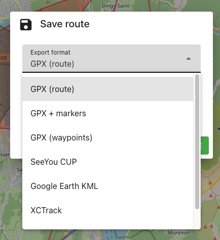
Formats
There are two distinct recording formats:
1. Save the route as a drawing:
This option allows the route to be displayed on a mapping application as a simple trace.
- Advantage: no constraints
- Disadvantage: no indication of distance to the next point in the route. GPX format is required
2. Save the route as a succession of waypoints to reach:
The application will consider each of these tags to be reached. This is the principle of competitive routes. If for any reason or another you decide to go directly to the second tag, the application will always indicate the direction to the first waypoint.
- Advantage: displays distance and bearing to the next point in real-time
- Disadvantage: manual intervention required to skip a tag
Tip
Regardless of the chosen recording option, you can recover the route in XCNav and record it in a different format.
GPX Recording (Route)
Recording in GPX format as "route drawing". If you have added markers, they will not be included in the recording. This format is not compatible with applications such as XCTrack or XCSoar. Recommended for smartphone mapping apps. A drawing with a line connecting each end point of route segments will be obtained.
Recording GPX + Markers
Similar to the previous format, if you have added markers, they will be included in the recording. A drawing with a line connecting each end point of route segments will be obtained. Each marker will be represented by an icon similar to "pin".
Recording GPX Format Waypoints
Only the coordinates of the end points of the segments will be recorded. The route will only appear as a succession of waypoints to reach.
Recording SeeYou (Cup)
Format used by instruments such as Naviter, among others. Only the end point coordinates of the segments will be recorded and will appear as a succession of waypoints to reach.
Recording Google Earth (KML)
In KML format, the route can be displayed as a tracing in Google Earth or another software that recognizes this format.
Recording XCTrack
Specific format for XCTrack software. After importation, it will be listed in the XCTrack/Waypoints folder. XCTrack also recognizes SeeYou and GPSDump files.
Recording GPSDump
Specific format for GPSDump software. Only the end point coordinates of the segments will be recorded.